
Showing posts with label Social. Show all posts
Showing posts with label Social. Show all posts
Saturday, February 09, 2019

Thursday, November 01, 2018
Cardinal Points
The cardinal points are: North, South, East and West.
The Sun rises in the East and sets in the West.
When the Sun is high in the sky, it´s midday.

The Earth is a sphere that rotates on its axis.
The Equator divides the Earth into the
Southern Hemisphere and the Northern Hemisphere.

Sunday, October 28, 2018
Our World: Map and Globe
Globes, maps, world maps and plans are different ways of representing our world.


Flat world map

Globe

Plan
Wednesday, October 10, 2018

Wednesday, September 19, 2018
Earth´s Movements: Rotation and Revolution
ROTATION is the movement of the Earth on its own axis.
To make a complete turn takes 24 hours that is exactly 1 day.
This movement causes Day and Night
REVOLUTION is the movement of the Earth around the Sun.
To make a complete revolution around the Sun takes 365 days that is exactly 1 year.
This movement causes the Seasons.
Friday, April 13, 2018
Sunday, April 08, 2018
Wednesday, February 14, 2018

Friday, January 26, 2018
Tuesday, December 12, 2017
Sunday, October 01, 2017
My School
My classroom is a place in my school...


Lots of people work in my school...
I learn lots of things at school!!

I do lots of things at school!...

Saturday, March 04, 2017
Unit 4: Spain
Spain is in the south of Europe and it is part of the Iberian Peninsula.
It also has two archipelagos: the Canary Islands and the Balearic Islands.
Spain has borders with:
- France and Andorra in the north
- Portugal in the west
There are also seas and an ocean around Spain´s coast:
- in the north the Cantabrian Sea
- in the west and south west the Atlantic Ocean
- in the south and east the Mediterranean Sea
Spain is divided into autonomous communities. There are 17 autonomous communities and 2 autonomous cities: Ceuta and Melilla.
Each autonomous community has:
- a capital
- a flag
- a coat of arms
- an anthem


It also has two archipelagos: the Canary Islands and the Balearic Islands.
Spain has borders with:
- France and Andorra in the north
- Portugal in the west
There are also seas and an ocean around Spain´s coast:
- in the north the Cantabrian Sea
- in the west and south west the Atlantic Ocean
- in the south and east the Mediterranean Sea
Spain is divided into autonomous communities. There are 17 autonomous communities and 2 autonomous cities: Ceuta and Melilla.
Each autonomous community has:
- a capital
- a flag
- a coat of arms
- an anthem

SPAIN´S RELIEF
Spain has different mountain ranges and a big plateau (an area of high flat land) in the centre called Meseta

SPAIN´S RIVERS
Spain´s most important rivers are: the Miño, the Duero, the Ebro, the Tajo, the Guadiana, the Guadalquivir, the Júcar and the Segura.

MIÑO
The source of the Miño is in Sierra de Meira and it flows into the Atlantic Ocean.
The Sil is its main tributary.
DUERO
The source of the Duero is in Picos de Urbión and it flows into the Atlantic Ocean.
The Pisuerga and the Esla are its main tributaries.
EBRO
The source of the Ebro is in Fontibre spring, in Cantabria, and it flows into the Mediterranean Sea.
The Jalón is its main tributary.
TAJO
The source of the Tajo is in Sierra de Albarracín and it flows into the Atlantic Ocean.
The Jarama is its main tributary.
GUADIANA
The source of the Guadiana is in Lagunas de Ruidera and it flows into the Atlantic Ocean.
The Zácara is its main tributary.
GUADALQUIVIR
The source of the Guadalquivir is in Sierra de Cazorla and it flows into the Atlantic Ocean.
The Genil and the Gadajoz are its main tributaries.
The source of a river is the place where it begins.
The mouth of a river is the place where it ends and flows into the sea, ocean, lake or another river.
Tributaries are smaller rivers that flow into another rivers.

Saturday, January 07, 2017
Social - Unit 3: Europe
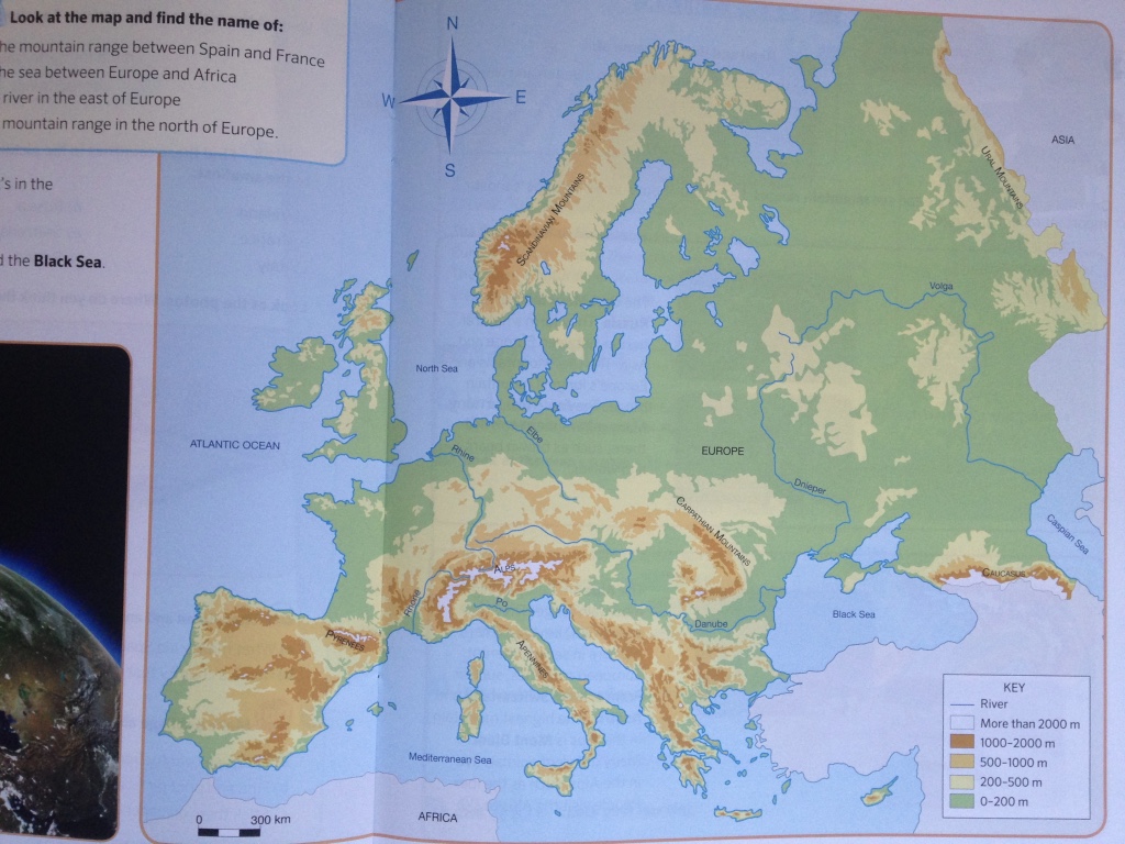
Europe is the second smallest continent in the world and it is in the Northern Hemisphere.
- to the north of Europe there is the Arctic Ocean
- to the south there is the Mediterranean Sea and the Black Sea
- to the west there is the Atlantic Ocean
- and to the east there is Asia
On relief maps of Europe we can see:
1. MOUNTAIN RANGES
Europe´s most important mountain ranges are:
- The Ural Mountains
They are in Russia and they form a natural border between Europe and Asia.
The Ural Mountains are Europe´s longest mountain range.
- The Alps
They are the highest mountain range in Europe.
The Alps are in seven different European countries, such as France, Italy, Switzerland and Austria.
The highest mountain in the Alps is Mont Blanc.
- The Scandinavian Mountains
They are on a peninsula in the north of Europe and form a natural border between Norway and Sweden.
They´re on of the oldest mountain ranges in the world.
2. RIVERS
Europe´s most important rivers are:
- The Volga
It is in Russia and it´s the longest river in Europe. It flows into the Caspian Sea.
- The Danube
It is the second longest river in Europe and flows into the Black Sea.
- The Rhine
It starts in the Alps and it flows into the North Sea.
On political maps of Europe we can see many countries and cities. There are 47 different countries in Europe and each one has its own traditions and, many, their own language.

We are going to study some of them:

Saturday, November 19, 2016
Social - Unit 2: The Continents
A continent is a big land mass.
There are five continents on Earth: Africa, America, Asia, Europe and Oceania.
Oceans are big masses of water around continents.
There are five oceans: Arctic Ocean, Atlantic Ocean, Indian Ocean, Pacific Ocean and Southern Ocean.
RIVERS
MOUNTAIN RANGES (Definition: A line or a group of mountains)

There are five continents on Earth: Africa, America, Asia, Europe and Oceania.
Oceans are big masses of water around continents.
There are five oceans: Arctic Ocean, Atlantic Ocean, Indian Ocean, Pacific Ocean and Southern Ocean.
- A relief map shows rivers, mountain ranges, islands and archipelagos.
RIVERS
- The Nile - It´s the longest rivers in te world. It´s in Africa. It flows into the Mediterranean Sea. There are lots of crocodiles there.
- The Amazon - It is not the longest river but it carries more water than the Nile. It´s in America. It flows into the Atlantic Ocean.
MOUNTAIN RANGES (Definition: A line or a group of mountains)
- The Himalayas - They´re the highest mountain range in the world. They´re in Asia. Mount Everest is the highest mountain in the world and it´s in the Himalayas.
- The Andes - They´re the longest mountain range in the world. They´re in America. Ojos del Salado is the highest volcano in the world and it´s in the Andes.
ISLANDS (Definition: It is land with sea all around it)
- Greenland - It´s the biggest island in the world. It´s between the Atlantic and the Arctic Oceans. It´s covered in ice.
- Madagascar - It´s the biggest island in Africa. It´s in the Indian Ocean. Lemurs live there.
ARCHIPELAGOS (Definition: It´s a group of islands in the same area)
- Indonesia - It´s the biggest archipelago in the world. It´s in Asia. It´s between the Indian and Pacific Oceans.
- The Philippines - It´s also in Asia. It´s in the Pacific Ocean.
- A political map shows countries and their borders and capitals (Definition: The main city of each country).
Let´s study some countries.
INDIA: It´s in Asia and its capital is New Delhi.
CANADA: It´s in America and its capital is Ottawa.
JAPAN: It´s in Asia and its capital is Tokyo.
ARGENTINA: It´s in America and its capital is Buenos Aires.

Let´s revise unit 1!
Let´s revise unit 1!
The Earth is our planet and it has two different parts: Blue part is water (Oceans) and green and brown part is land (Continents).

Representations of the Earth show the continents and the oceans. They also show rivers, seas, lakes, mountains, islands... and sometimes countries too. These representations are maps.
A relief map shows mountains ranges, rivers, seas, lakes, islands...

A political map shows countries, capitals and their borders.

The Earth is our planet and it has two different parts: Blue part is water (Oceans) and green and brown part is land (Continents).

Representations of the Earth show the continents and the oceans. They also show rivers, seas, lakes, mountains, islands... and sometimes countries too. These representations are maps.
A relief map shows mountains ranges, rivers, seas, lakes, islands...

A political map shows countries, capitals and their borders.

Thursday, April 28, 2016
Provinces of Spain
Spain has 50 provinces.
What´s the name of your province?
Which autonomous community has the most provinces?
Where is Valladolid? Where is Almería? Where is Cáceres?

Sunday, April 03, 2016
Our country: Spain
Spain is our country and it is divided into 17 autonomous communities and 2 autonomous cities (Ceuta and Melilla)

Mobile phones: Try this app "Geoios"


Mobile phones: Try this app "Geoios"
Spanish flag is red and yellow

Spain´s official language is Castellano (Spanish)
Saturday, February 27, 2016
Landforms
We are studying different landscapes...
- mountain landscapes
- coastal landscapes
- flat landscapes
- urban landscapes
- rural landscapes
All of them have different landforms.
Let´s learn about landforms!!
- mountain landscapes
- coastal landscapes
- flat landscapes
- urban landscapes
- rural landscapes
All of them have different landforms.
Let´s learn about landforms!!
Sunday, January 31, 2016
Layers of atmosphere
The atmosphere is a layer of gases surrounding the Earth; it protects our planet and we need to take care of it.
Subscribe to:
Posts (Atom)